Skelmersdale Heritage Society
Home
A Brief History
Family History
Upcoming Events
Your Memories
Gallery
Documents
Member
Contact
Census Returns
Home
A Brief History
Family History
Upcoming Events
Your Memories
Gallery
Documents
Member
Contact
Census Returns
Aerial Views
Home
Back
Aerial Views
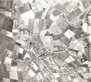
Ariel View of Skelmersdale 1945
Aerial Views
Church Road, Kiln Lane, High Street 1969
Aerial Views
Gillibrands Road 1969
Aerial Views
Stanley Industrial Estate 1969
Aerial Views
New Church Farm 1969
Aerial Views
Berry Street, Mill Lane 1969
Aerial Views, Farms, Upholland
Moorside Farm .
Aerial Views
Mill Lane, Berry Street. 1969
Aerial Views
Church Road and New Church Farm 1969
Aerial Views
Church Road, Kiln lane and High Street 1969
Aerial Views
Half Mile Island 1969
Aerial Views
Glebe Road, Gillibrands 1969
Aerial Views
Glenburn School playing fields 1969
Aerial Views
Gillibrands, Skelmersdale 1969
Aerial Views
New Church Farm 1969
Aerial Views
New church Farm 1969
Aerial Views
New Church Farm 1969
Aerial Views
Stanley Industrial Estate 1969
Aerial Views
Wigan Road 1969
Aerial Views
Summer Street 1969
Aerial Views
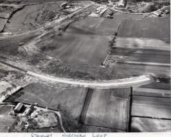
Stanley Northern loop 1969
1
Login
Remember me
Forgot Password?
Sign in
Lost your password? Please enter your username or email address. You will receive a link to create a new password via email.
Email Reset Link
body::-webkit-scrollbar { width: 7px; } body::-webkit-scrollbar-track { border-radius: 10px; background: #f0f0f0; } body::-webkit-scrollbar-thumb { border-radius: 50px; background: #dfdbdb }